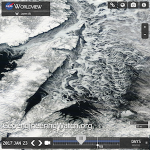
Search Results for: eastern us colder than average
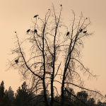
Record High Temperatures In The Arctic While The Eastern US Freezes

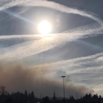
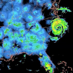
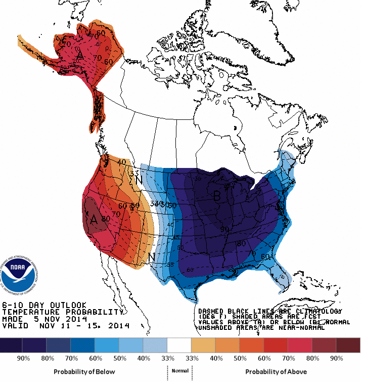
Temperatures in the Arctic as high as 50 degrees while the mercury is nearly 30 below at some locations in the Eastern US, what is wrong with this picture?
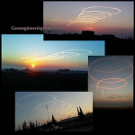
Climate engineering is tearing the biosphere’s life support systems apart. The geoengineering elephant in the room continues to wreak havoc on the planet while the entire climate science community pretends not to know a thing about the climate engineering insanity. All are needed to help sound the alarm by passing out credible data to those that still have no clue about what is going on in our skies. Start “spot fires” of awareness everywhere you can, every day counts.Taking a daily compass heading of data from multiple sources is imperative for reaching solid conclusions on exactly what is unfolding. We must all work together, everything depends on our unity in this battle. The article below does not mention climate engineering as is to be expected, but it does make clear the unprecedented conditions that are occurring.
Dane Wigington
geoengineeringwatch.org
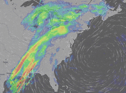
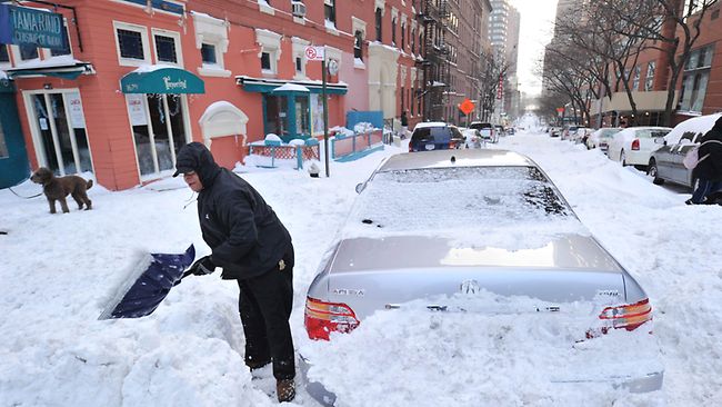
U.S. is turning into an icebox this week. The record temps to prove it
Source: Mashable
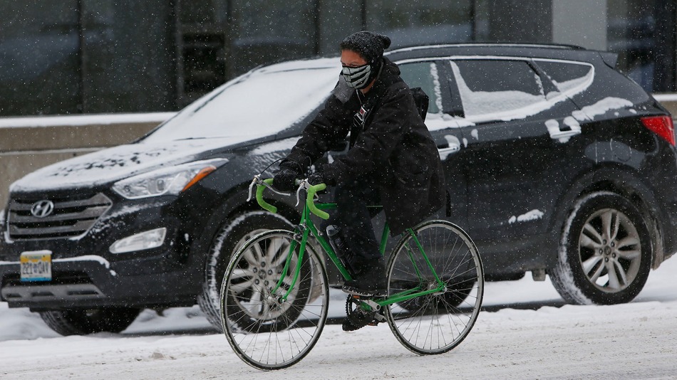
A bicyclist is bundled up to deal with the elements while riding hrough downtown Denver, Wednesday, Nov. 12, 2014.
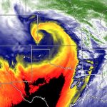
An extreme weather pattern that began with a super typhoon in the Pacific Ocean is now gripping half of the United States with record-smashing cold. Essentially, the U.S. — from the Mid-Atlantic to the Gulf Coast, northward to the Canadian border, and all the way west to Portland, Oregon — has turned into an icebox.
At the same time, record warmth has surged into Alaska and Northwest Canada, as the upper level weather highway known as the jet stream is diverted at least a thousand miles north of its usual position at this time of year, before plunging so far south over the U.S. that the air in Illinois is being sourced straight from Siberia.
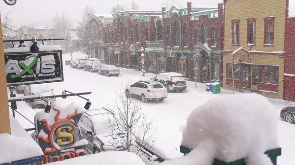
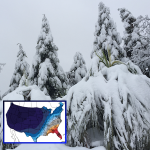
Snowy scene in Breckenridge! Two days until opening day and MORE snow is on the way.
Here are some of the most noteworthy weather records set over the past few days. We’ll see more over the course of the next week, as at least one (perhaps two) more rounds of Arctic air invade the U.S. from our neighbor to the north.
- Minus-14 degrees Fahrenheit: In Denver, the temperature dropped to minus-14 degrees Fahrenheit on Thursday morning, tying for the second coldest all-time temperature recorded there in the month of November. The last time this happened was Nov. 27, 1887; the all-time record low there is minus-18 degrees Fahrenheit, set in 1877. The high temperature at Denver International Airport only reached 6 degrees Fahrenheit on Nov. 12, a record low maximum temperature for the date, beating the old record of 9 degrees, which was set in 1916.
Robert Henson, a meteorologist at the University Corporation for Atmospheric Research in Boulder, Colo., posted on Facebook that in Denver’s recorded history of 142 Novembers, the only November days colder than Wednesday were in 1880 and 1919. Denver may see the first-ever streak of three November days with a high temperature below 20 degrees Fahrenheit, Henson added.
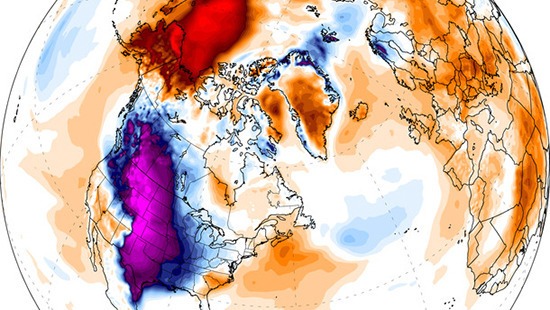
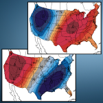
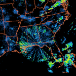
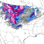
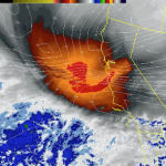
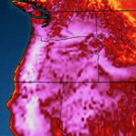
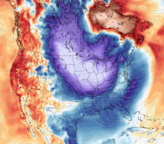
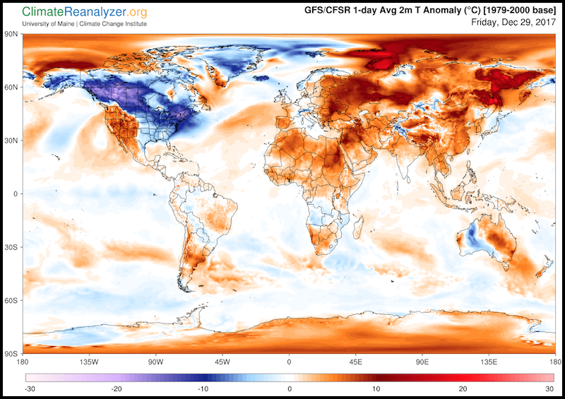
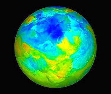
Temperature departures from average for Nov. 12, 2014, showing the unusual cold across the lower 48 states and unusually mild weather in Alaska and the Arctic.
- Minus-27 degrees Fahrenheit: In Casper, Wyoming, the extremely low temperature on Wednesday evening set a daily record low as well as a monthly low. This beat the previous monthly record low of minus-21 degrees Fahrenheit, set on Nov. 23, 1985. These temperatures are about 50 degrees Fahrenheit below average for this time of year, and cold weather of this magnitude is typically experienced there beginning in December (if at all). The earliest Wyoming had reached such a cold temperature was on Dec. 5, 1972, the National Weather Service said. Climate data there dates back to 1939.
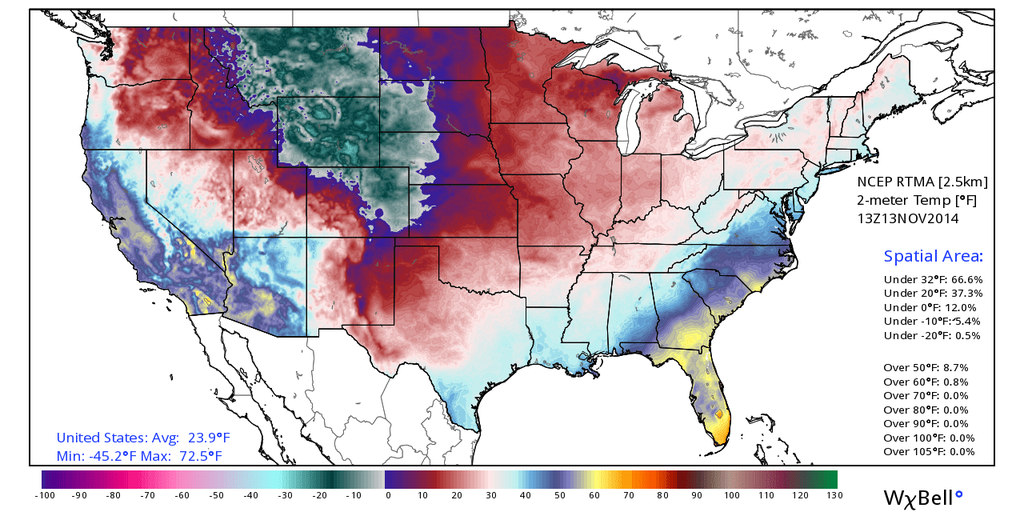
U.S. temperatures on Nov. 13, 2014, showing the core of the cold air parked over the Northwest Rockies, but spilling east and west to cover most of the country.
- Minus-21 degrees Fahrenheit: It was Livingston, Montana’s coldest temperature for so early in the season on Nov. 12. However, it has previously been much colder than this in November, with a reading of minus-31 degrees Fahrenheit on Nov. 13, 1959.
- 21 degrees Fahrenheit: On Nov. 12, Amarillo, Texas, set its coldest daily high temperature on record for so early in the season.
- 14 degrees Fahrenheit: On Nov. 12, Goodland, Kansas, set a record for the coldest daily high temperature for so early in the season.
- As the frigid airmass blows across the relatively warm waters of the Great Lakes, we’re likely going to see prodigious amounts of lake effect snow during the next week. As the Weather Prediction Center (WPC) put it in a forecast discussion on Thursday morning:
A VERY PROLONGED PERIOD OF LOCAL LAKE-EFFECT SNOWFALL EVENTS WILL PREVAIL AT VARIOUS TIMES ACROSS ALL 5 GREAT LAKES. WITH SIGNIFICANT SNOWS ALREADY PRESENT…HARD TO IMAGINE HOW MUCH MORE SNOWFALL IS POSSIBLE…PROLIFIC? NUMBERS ARE POSSIBLE. ANOMALOUS? CERTAINLY.
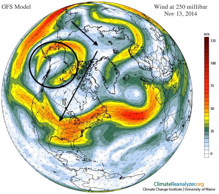
Map of the jet stream on Nov. 13, 2014, with an oval around the major dome of high pressure over Alaska, and arrows showing the frigid air being routed over the North Pole and into the lower 48 states.
The warm side of this weather pattern:
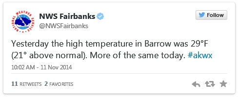
- 50 degrees Fahrenheit: A record high temperature was set in King Salmon, Alaska, on Nov. 12. This beats the old record of 48 degrees Fahrenheit in 1986. The typical high temperature in King Salmon at this time of year is 31 degrees Fahrenheit.
- At least 41 degrees Fahrenheit: On Thursday, McGrath, Alaska, had already set a daily high temperature record as of 4:49 a.m. local time, at 41 degrees Fahrenheit. The actual high temperature will climb further during the day. McGrath will likely also set a record high minimum temperature record of 38 degrees Fahrenheit, which breaks the old record of 30 degrees from 2000.
- The cold air is going to spread all the way to the West Coast as well as the Southwest U.S. with time, and it will ooze into the Southeast, including Florida, as well, according to the WPC. Some models are suggesting that a snow event may take shape along the East Coast next week, but there is a lot of uncertainty regarding that scenario.The weather pattern is leading to a classic episode of what climate scientists have labeled the “warm Arctic, cold continents” pattern, something that has been seen with increasing frequency in recent years. Studies have tied this particular pattern in part to rapid Arctic climate change as a result of manmade global warming, although this is still a subject of debate within the mainstream climate science community.
Source: Mashable
Geoengineered Winter, 2019
Dane Wigington
geoengineeringwatch.org
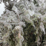
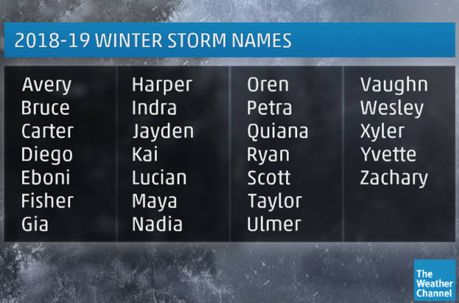
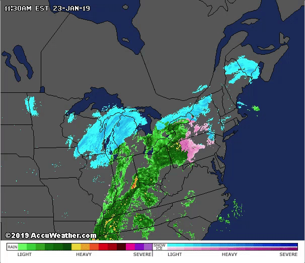
Climate engineering operations continue to create winter weather chaos in parts of the US, Canada and Europe. Chemical ice nucleation elements are a core component of global geoengineering programs. Winter weather whiplash, freezing rain, freezing drizzle / fog, and “thunder snow” conditions, all are indicative of chemical ice nucleation materials being dispersed into available atmospheric moisture. Ice nucleating elements create an endothermic (energy absorbing) reaction that, in turn, produces a colder, heavier air mass. The heavy dense air then sinks to ground surface levels. This shallow layer of cold air lowers surface temperatures and thus produces the sensationalized headlines of cold weather that the climate engineers and the power structure corporate media are seeking. “Winter Storm Harper” recently took its toll on specific regions of the Eastern US. “Winter Storm Indra” is now winding down with less impact than than the climate engineers had originally hoped (or scheduled) to achieve. Naming “winter storms” adds to the sensationalizing of these completely engineered events.
Corporate media faithfully follows the scripts and talking points they are given in their coverage of the completely engineered “winter weather”, while completely omitting the unfolding planetary meltdowns occurring in so many other locations around the world. The scripted nature of mainstream meteorologist's narratives is not hard to see through. Corporate meteorologists are playing the part of cover-up for the climate engineering programs.
The temperatures and precipitation types (frozen or liquid) in the current condition and forecast screenshots below should be examined and considered. The scheduled weather in three locations were captured, Jamestown, NY, Binghamton, NY, and Nashville, TN.
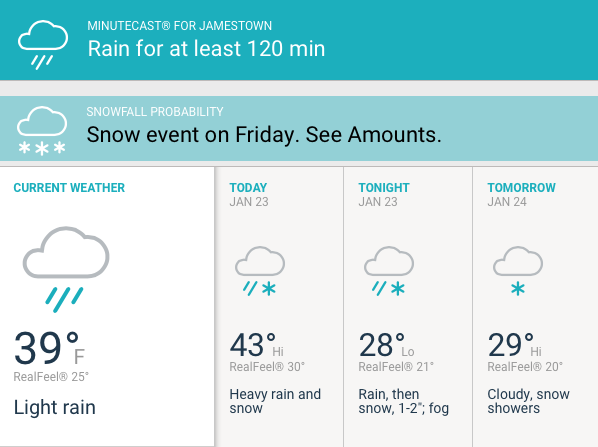
Why is snow falling at 43 degrees? Why is it still raining at 28 degrees?
The next "forecast" capture was for Binghamton, NY.
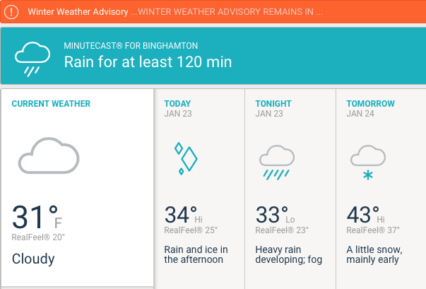
Why is ice falling at 34 degrees? Then back to rain at 33 degrees? Then snow at 43 degrees?
The final "forecast" capture is for Nashville, TN.
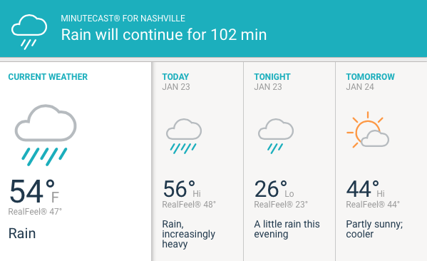
This weather information screen for Nashville, TN, is also perplexing. The flow of rain over Nashville is coming right out of the Gulf of Mexico, thus the high temperatures of 56 degrees and rain. This same flow of warmer moisture somehow “turns over” to snow further north, with temperatures still being far above freezing. The “forecast” map above (scheduled weather) calls for an extremely anomalous temperature plunge of some 30 degrees with continuous rain. With a constant flow of warmer moisture out of the south, why would there be such a sudden 30 degree temperature drop? Generally, day to night temperatures only vary by a few degrees when a constant flow of precipitation is occurring. Why would it still be raining at 26 degrees?
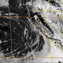
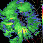
The animation below reveals precipitation flow and wind patterns that were present during the peak of "Winter Storm Indra".
In this animation view of precipitation and wind, the source of moisture for “Winter Storm Indra” can clearly be seen. Warm Gulf of Mexico moisture and temperate wind from the south western Atlantic Ocean are primary components of "Winter Storm Indra". The same conditions were present for "Winter Storm Harper" and countless other "winter storms" in recent years. Are such extreme anomalies an act of nature? Or the result of climate engineering operations?
The next animation even more clearly reveals the very unlikely and questionable source of moisture for a "winter storm".
The flow of temperate moisture from the Gulf of Mexico (shown) was the primary fuel for “Winter Storm Indra”. Some regions in this animation can be seen flashing from liquid precipitation (rain), to frozen (ice storm or snow), and back again. Such a “change over” at above freezing temperatures can only occur when an unnatural ice nucleating factor is in the equation, that factor is chemical ice nucleation for weather modification elements. These are patented processes.
Engineered winter events, chemical ice nucleation, and its effects, can be viewed in a 16+ minute segment of the presentation below (from 1:22:54 to 1:38:00), the video is pre-set to start at the beginning of this section on engineering winter.
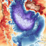
Below is the NOAA forecast (scheduled) departure from normal high temperature map for late January, 2019. The extreme opposites of temperatures from one side of the country to the other are historically unprecedented (though are now becoming the norm in recent years).
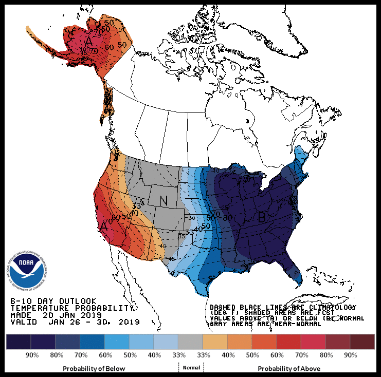
While the Eastern US is scheduled for yet more engineered cool-down scenarios, locations like Alaska have been kept warm and dry. Record shattering heat is persisting and accelerating in other parts of the world as well, Australia is only one example of many.
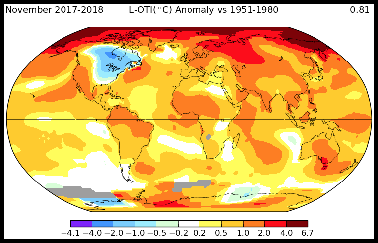
What is the global temperature perspective? The GISS departure from normal high temperature map below is for a recent 1 year period. This average temperature compilation map is extremely revealing and should be carefully considered. The only consistently anomalously cool-down zone on the planet is the eastern half of the North American continent. Is it just a coincidence that the country with by far the world's largest military and air force (and thus by far the largest climate engineering operations) has had the only consistent and extremely anomalous cool-downs over its most populated regions over extended spans of time? Again, is this just a coincidence? No.
Radically increasing winter weather whiplash is not an act of nature, it is a result of covert climate engineering operations. There can be no legitimate discussion of the climate without first and foremost addressing the climate engineering / geoengineering / solar radiation management issue. Further, there can be no legitimate discussion of geoengineering / climate engineering without addressing the engineered “winter weather” events that utilize jet stream manipulation and patented processes of chemical ice nucleation for weather modification.
The short video report below provides yet more in depth detail of the ongoing freeze / fry scenarios being created by climate engineering operations.
Are there US patents for chemical ice nucleation for weather modification? Yes, one example is below:
https://www.geoengineeringwatch.org/creating-snow-storms-the-knollenberg-patent/
More examples of GeoengineeringWatch.org articles covering engineered winter events and operations:
https://www.geoengineeringwatch.org/engineered-winter-the-deception-of-the-us-population/
https://www.geoengineeringwatch.org/manufacturing-winter-with-geoengineering/
https://www.geoengineeringwatch.org/category/geoengineering/results-of/ice-nucleated-snow/
https://www.geoengineeringwatch.org/the-engineered-winter-deception-chemical-ice-nucleation/
https://www.geoengineeringwatch.org/engineered-winter-weather-whiplash/
https://www.geoengineeringwatch.org/engineered-winter-engineered-drought/
Our planet's life support systems are being systematically decimated by the ongoing climate engineering insanity, it must be exposed and halted. Help us in this most critical battle to sound the alarm, share credible data from a credible source, make your voice heard.
DW
May be freely reprinted, so long as the text is unaltered, all hyperlinks are left intact, and credit for the article is prominently given to geoengineeringwatch.org and the article’s author with a hyperlink back to the original story.
Geoengineered Winter Weather, The Chemical Ice Nucleation Factor

Dane Wigington
geoengineeringwatch.org
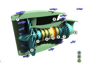
The climate engineers have the power to chemically cool-down surface temperatures when enough atmospheric moisture is available to them. The more heavily and extensively the geoengineers utilize chemical ice nucleating materials, the more extreme the surface cooling that they can create. This is not speculation, but verifiable fact proven by patented processes. One example is below.
Click the image to view highlighted patent
Mainstream media covered the fact that Chinese scientists are engineering snowstorms, are we to believe that the US government and others aren't doing the same?
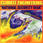
The US military is as large as the next 10 largest militaries combined, thus they have the ability to carry out climate engineering (weather warfare) operations on the largest scale by far. Not only have US military commanders stated that the disintegrating climate is the greatest national security threat, they have long since stated their objective of "owning the weather". Are we to believe that our government would ask our permission before deploying climate engineering operations? In fact, our government's own documents prove climate engineering has been ongoing for decades. The “departure from normal high temperature” map below (from Dec 29, 2017) clearly revealed where surface temperatures were cold, and where they were not.
The arc of below normal surface temperatures began at the Hawaiian islands and rotated clockwise up and over the “ridiculously resilient ridge” of drought creating a geoengineered high pressure zone that was created over the US West (from ionosphere heater installations like HAARP), then descends back down to the eastern US. This freeze / fry scenario has been ongoing in recent years
In order to engineer an end of year cool-down for parts of the US and Canada, the flow of moisture from the Pacific (that was until recently directed completely around California) was chemically nucleated by the climate engineers. What happens when these endothermic reacting materials rain down on far above freezing bodies of water like Lake Michigan? (the majority of Lake Michigan is still at nearly 45 degrees F) Perfectly spherical ice balls form and start washing up on shorelines. The chemical nucleating elements form a nucleus around which ice continues to form.
How about all that temporary ice along the US East Coast which the media did their best to sensationalize? Did anyone bother to check the ocean temperatures?
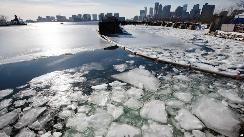
Sea ice floats in Boston Harbor, Jan. 3, 2018, in Boston. Photo credit: AP
Why is so much ice forming on ocean waters that are 40 degrees F or higher? This fact should also be remembered and considered, sea water does not freeze until it reaches 28.4 degrees F. “Slush Waves” were also recorded along the coast near Boston, why are no official sources questioning this? Why are no official sources offering any reasonable explanations for such a phenomenon when ocean temperatures are 40 degrees F or higher? The answer is because they are not allowed to tell the truth. The illegal federal gag order on all National Weather Service (NWS) and all National Oceanic and Atmospheric (NOAA) employees should be a glaring red flag. Surface ice storms are also now a constant threat due to the chemical ice nucleating elements reaching the surface before solidifying.
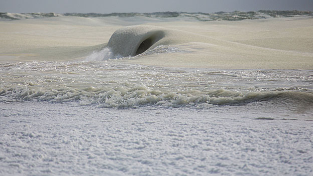
Photo credit: Jonathan Nimerfroh
How warm is the East Coast scheduled to get after the engineered weather whiplash cool-down passes? The “departure from normal high temperature” map below paints a shocking picture of East Coast warmth (in close proximity to a chemically nucleated cold zone in the center of the US) that was scheduled to follow on the heals of the media hyped (and completely engineered) “winter storms”. Will the geoengineers be able to alter the outcome of this "forecast" with yet another engineered cooldown? Winter storm “Hunter” is the next theatrically named creation of the climate engineers that will follow the temporary weather whiplash warm-up.

The top 3 superpowers (USA, China, and Russia) have the largest militaries, and thus the greatest ability to effect the climate with their ongoing chemical ice nucleation cool-down operations. It is important to remember and consider that the majority of nations are either actively or passively participating in the global climate intervention programs. Comparing the more recent scheduled temperature anomaly forecast map below with the map shown earlier in this post reveals a number of profound weather whiplash changes occurring in the space of only a few days. Greenland has gone from far below normal surface temperatures back to far above normal temperatures, the eastern US has done the same. Conversely, portions of Russia and China have done the opposite, going from far above normal to below normal. The geoengineered winter weather whiplash scenarios will continue to worsen rapidly, patented chemical ice nucleation processes are a primary factor. It must be remembered and considered that all "predictions" (scheduled weather) are in a state of constant flux. So much depends on what the climate engineers choose to do (or not to do) at any given window of time.
Headlines from Siberia reveal an incident of uniformly spherical "ice boulders" suddenly washing up on the shores of Nyda, Russia. Are we to believe this is only an "act of nature" as "official sources" have told us?

Photo credit: Ekaterina Chernykh
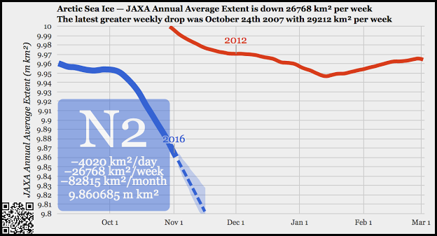
Why would the "ice boulders" occur with Arctic sea ice at record low levels? Why would perfectly spherical "ice balls" occur at all? 2012 was the previous record Arctic ice low for this time of year, 2016 has shattered that former record. 2017 has brought yet another new record low level of Arctic sea ice.
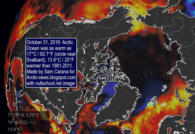
Why would such formations occur from the record warm Arctic Ocean? Sea temperatures in some zones of the Arctic Ocean have been as much as 25 degrees above the 30 year average. This average was taken from 1981-2011, when the ocean temperatures were already warmer than the pre-industrial era.
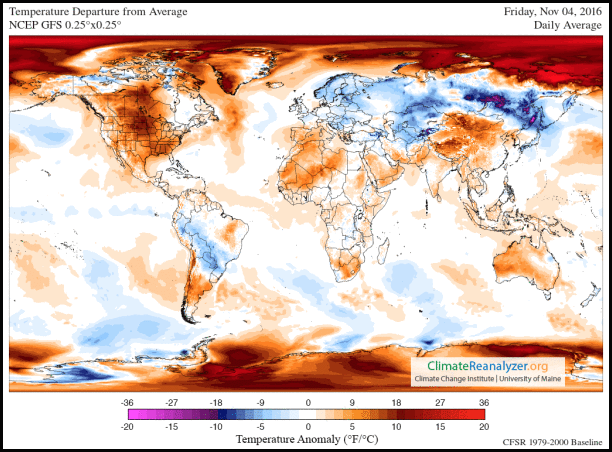
Why are governments and media doing all they can to hide the reality of the record warm Arctic from the public? There are many reasons, none of them are benevolent. Temperatures and ice melt in the polar regions are going completely off the charts as the "departure from normal temperature" map below makes clear.
Siberia is undergoing massive engineered cooling assaults, but the extremely rapid warming of the planet is undeniable and climate engineering is helping to fuel the overall fire. Are the climate engineers trying desperately to reduce the methane "blowouts" that are occurring in Siberia due to rapidly thawing methane permafrost deposits? Whatever the case, the short term engineered (and highly toxic) cool-downs come at the cost of a worsened overall warming. 2017 is now officially the 2nd warmest year ever recorded, narrowly missing the record warm year of 2016, which broke the record set in 2015, which broke the record set in 2014.
Photo credit: Andrey Naumenko
Again, the "experts" tell us that the "ice boulder" phenomenon is a "natural" occurrence. But if this is so, why is there no long term historical record (or pre 1945 photographs) of this phenomenon occurring? There is no such long term record (pre 1945) because the ridiculously uniform "ice boulders" are absolutely not natural. The climate engineers became very active in the polar regions immediately after the end of WWll, historical data confirms this fact. About the ice anomalies being "natural, the "experts" are simply lying, as they are paid to do. We are all swimming in a sea of lies and deception that is propagated by countless individuals in academia, media, and "official sources", who have completely betrayed humanity in exchange for a paycheck and a pension. When will the population reactivate their sense of sanity and reason? When will the population recognize that our geoengineered skies should not look like they do? When will the population face the fact that steel structure high-rise buildings (building 7 on 911) don't just fall down because of an office furniture fire on the lower floors? And why can't the masses discern that miles of shorelines covered with almost perfectly uniform and symmetrical "ice boulders" is completely unnatural?
DW
Below is an article on chemical ice nucleation that I first posted in November of 2015. The information it contains is every bit as relevant now as it was then.
The Engineered Winter Deception, Chemical Ice Nucleation
All around the globe, extreme, destructive, and unprecedented "frozen precipitation" events are occurring. A great many of these events begin at temperature ranges far above the freezing point (though temperatures on the ground can drop precipitously as the nucleation process unfolds). Why? Most have never heard of "chemical ice nucleation for weather modification", but patents exist for this process and the Chinese government has long since admitted to engineering frozen precipitation events. The 90 second video below is astounding, a 200 foot wide river of ice flowing through the Saudi desert on November 2nd, 2015.
Extreme hail events are happening with alarming frequency, often in the most unlikely locations where such storms have not historically occurred.
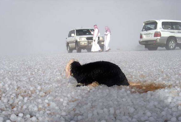
"Ice storm" hits Saudi Arabia in Early November, 2015
When moisture laden storms are saturated with artificial/chemical ice nucleating elements (due to the destructive attempt by the climate engineers to temporarily cool-down ground temperatures on the ground), storms that would have been a deluge of rain become unprecedented onslaughts of frozen precipitation.

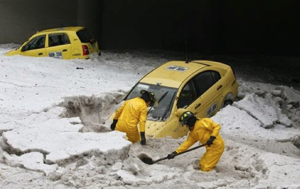
Record hail storm in Quito, Ecuador, February 14, 2015
The damage being inflicted by the rapidly increasing hail storms is massive and growing.
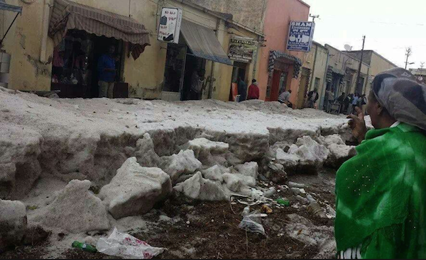
Record hail event, Bogata Columbia, February 22, 2015
Africa is also being subjected to unprecedented hail events.
A record shattering 3 feet of hail is dumped on the East African nation of Eritrea, March 14, 2014
Below is a shocking photo of "ice balls" piled up on the shores of Lake Michigan. Why is there no long term historical record of such a profound phenomenon? Chemical ice nucleating materials form a central core of ice that builds up around itself. The motion of the waves then contribute to the spherical shape.
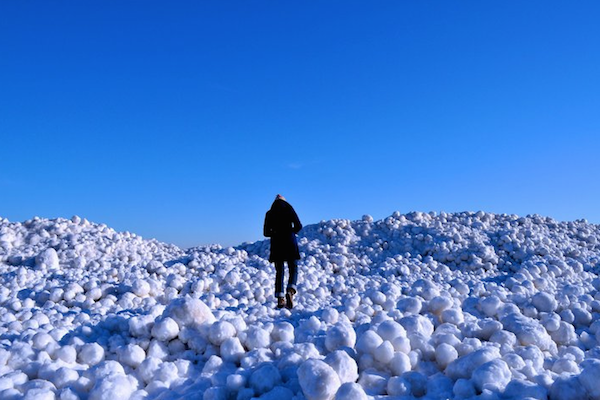
"Ice balls" have formed and accumulated on Lake Michigan in the last few years, why? Such "ice balls" have even formed on lake water that was 40 degrees, how is this possible at temperatures far above the normal freezing point? Without chemical ice nucleation, it isn't possible.
What is occurring on the shores of distant seas? Yet more "ice balls" have appeared in recent years.

"Ice balls" on the Baltic Coast in Northern Poland. "Official" sources say this recent unprecedented phenomenon is just "natural", are we to believe them?
Other European countries are noting the same phenomenon.
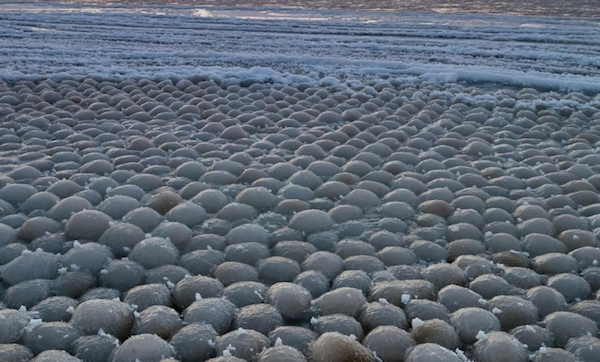
Ice balls on the coast of Finland. The "official" explanation for this recent mysterious anomaly? Again, we are told it is a "natural" occurrence.
How natural do these "ice pancakes" look in the photo below?

CNN news called these "ice pancakes" "mysterious". This phenomenon has also been observed on various lakes and rivers in recent years. It is the extreme uniformity of these formations that separates them from any natural phenomenon. Chemical nucleation materials are the core causal factor that produce the recent rash of profound ice formations.
"Freezing rain" has now become commonplace. Extreme "ice storms" are wreaking havoc all over the globe. Depending on atmospheric conditions and temperatures, precipitation from storms that have been sprayed with chemical ice nucleating materials can reach the ground before actually freezing.
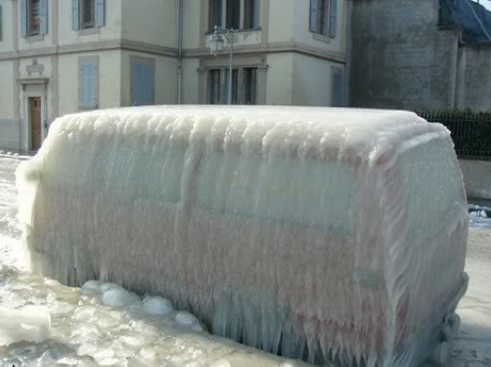
This vehicle photo was taken in Versoix, Switzerland. Formerly unprecedented ice storms have now become the norm as the geoengineers do their best to create temporary chemical cool-downs in a rapidly warming world.
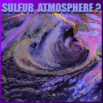
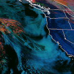
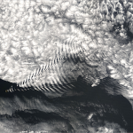
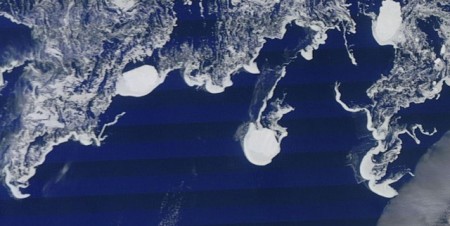
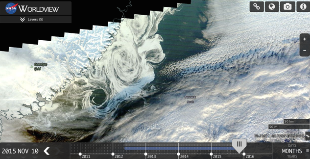
Where can the most profound chemical ice nucleation examples be seen? The satellite photos below show completely unnatural ice formation structures on the Arctic ocean, September 15th, 2015. Arctic ocean temperatures have persisted at record high levels and the warming continues to worsen. Why would ice form in open water under such conditions, and in a manner that is completely different than the normal ice pack winter expansion? And all this during a year that has had record warmth and record ice melt in the Arctic? Surface ice formation on record warm seas worsens the overall warming by trapping the heat below.

Another satellite photo taken over the Arctic Ocean, September 15, 2015. Extremely anomalous sea surface ice formation is clearly evident.
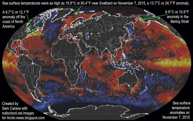
Even into November, 2015, astoundingly high ocean temperatures have persisted and continue to shatter records. The map below clearly shows that sea surface temperatures were as much as 24.7 degrees ABOVE NORMAL in the Arctic ocean on November 7, 2015.
The excerpt below was taken from a recently posted Article from "Arctic News", it should be read carefully. Arctic news describes the effects of atmospheric particulates (primarily from geoengineering which Arctic news refuses to admit to). They then state clearly the negative overall effects of these particulates (again, a result of geoengineering). And at the end of the article from which this excerpt was taken, Arctic News and the Arctic Methane Emergency Group calls for global geoengineering to be deployed immediately, as if it has not already been going on for over 6 decades in clear view and causing catastrophic effects. We must all diligently "sift the baby from the bathwater" so to speak. Though the front line data from Arctic news is accurate and verifiable from other sources, their constant call for geoegineering to commence is extremely alarming.
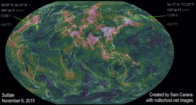
Aerosols
Particulates, in particular sulfate, can provide short-term cooling of the sea surface. Large amounts of sulfate are emitted from industrial areas in the east of North America and in East Asia. On the Northern Hemisphere, the Coriolis effect makes that such emissions will typically reach areas over the nearby ocean to the east of such industrial areas, resulting in the sea surface there being cooled substantially, until the particulates have fallen out of the sky. Since the sulfate is emitted on an ongoing basis, the cooling effect continues without much interruption.
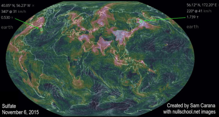
This sulfate has a cooling effect on areas of the sea surface where ocean currents are moving warm water toward the Arctic Ocean. Because the sea surface gets colder, there is less evaporation, and thus less heat transfer from the ocean to the atmosphere during the time it takes for the water to reach the Arctic Ocean. As a result, water below the sea surface remains warmer as it moves toward the Arctic Ocean.
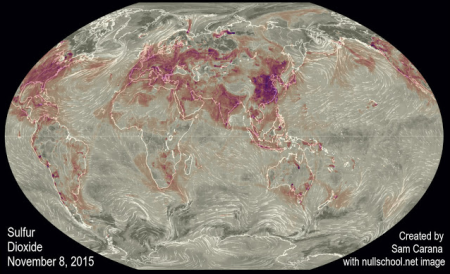
Similarly, as illustrated by above image, sulfur dioxide emitted in industrial areas in North America and East Asia can extend over the oceans, cooling the surface water of currents that are moving water toward the Arctic Ocean.

So the overall conclusion from Arctic News is that the atmospheric particulates are making a bad situation worse, not better. Yet, they continue to call for geoengineering deployment as if that is not the source of "atmospheric pollution" they have just condemned.
Below is a recent satellite photo of the sea surface off the coast of Greenland. Again we see an extremely anomalous and unprecedented pattern of ice formations like those shown earlier in this article. The massive chemical ice nucleation efforts in the Arctic, by the geoengineers, is undeniable.
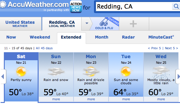
The AccuWeather "forecast" (scheduled weather) for November 16-20, 2015, shows snow with a daytime high of 59 degrees and a night time low of 40 degrees. Why?

In the next map, we see snow again called for on the 22nd with the same temperatures as the earlier forecast, yet, on the 25th only rain is called for with much colder low temperatures? Snow is now often reported at temperatures up to 50 degrees and even above, welcome to the world of chemical ice nucleation. As previously mentioned, there are patents for such processes, and again, the Chinese scientists have openly admitted their programs to create engineered snow storms.
What scenario are the geoengineers creating in the US with their chemical ice nucleated cool-downs? The exact antithesis of what has been the case in the US for the previous 3 winters. The extreme scenario shown in the most current NOAA map below is historically unprecedented, but in recent years has become the norm.
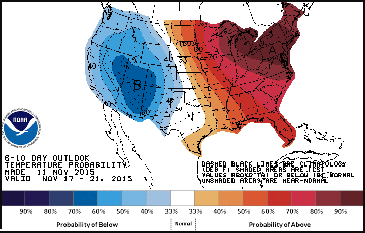
The "scheduled" weather from the geoengineers is for temperatures to be up to 20 degrees below normal in the West, and 20 or more degrees above normal in the East.
Chemical ice nucleation of storms and precipitation does create a cold dense layer of air on the ground level that can drastically lower temperatures temporarily. But what is the overall cost? A decimated climate system, a worsened overall warming of the planet, and total contamination of the atmosphere and surface of our planet (due to the highly toxic fallout from the climate engineering programs). If you think your winter weather is natural, think again. Exposing the ongoing climate engineering insanity is challenge we must all face head on, make your voice heard in this battle. Forward solid information to all those that need to know and don't. Make every day count in this most critical fight.
DW
May be freely reprinted, so long as the text is unaltered, all hyperlinks are left intact, and credit for the article is prominently given to geoengineeringwatch.org and the article’s author with a hyperlink back to the original story.
The Big Unchill
Source: The Boston Globe, written by David Abel
The Big Unchill
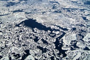
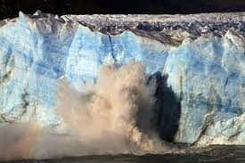
The Arctic ice is melting faster than ever recorded, the warmth tied to the emissions of modern life. But it is the ancient ways at the top of the world that are most at risk.
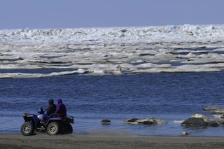
BARROW, Alaska — A mile off the coast of the continent’s northernmost city, Josh Jones gunned his four-wheeler over ridges of buckling ice and through pools of turquoise water, where normally there would be a vast sheen of ice and snow.
Escorted by an Eskimo guard toting a shotgun to protect them from roving polar bears, Jones and a fellow climate researcher were racing to retrieve scientific instruments that gauge the thickness of the ice, which they worried could be lost to the uncommonly rapid melt of the Arctic Ocean.
They were also in a race with much bigger stakes.
In previous years when making the trip out here to set up their observatory, temperatures had been so raw that Jones’s eyelids froze. On this day early last month, it was a balmy — for Barrow — 41 degrees. When they arrived at the observatory, which was surrounded by sprawling melt ponds, they stripped off their parkas and rolled up their sleeves.
Their wind turbine and other equipment had collapsed in the melting ice. They’d almost lost their all-terrain vehicle, too, when it lurched into a sinkhole and stalled in a knee-deep pool of slush.
“Not a good sign,” Jones deadpanned.
Here, as close to the top of the world as you can get in America, the signs are serious indeed: The Arctic Ocean is melting faster than at any time on record. This February, the sea ice that stretches from North America to Russia reached its lowest-known winter extent and began melting 15 days earlier than usual. That continued a three-decade trend that has seen the ocean’s ice lose about 65 percent of its mass and about half of its reach during the summer. In 20 or 30 more years, the Arctic Ocean could be nearly devoid of ice in the summer, climate scientists believe.


SOURCE: Stanford Report," September 30, 2014; Skeptical Science, "A Rough Guide to the Jet Stream"
James Abundis / Globe Staff
But the changes that are incipient here in New England are already acute in Barrow, where the average temperature has risen 3.6 degrees since 1921 — more than twice the rise of average global temperatures.
“Barrow is among the fastest-warming land areas in the world,” said Rick Thoman, a climate scientist at the National Weather Service in Fairbanks.


SOURCE: National Weather Service Alaska Region
James Abundis / Globe Staff
And the effects on the way of life here — long preserved against change by remoteness and the desperate cold — have been profound. Life as they knew it for the 4,300 who call this treeless tract of tundra 300 miles north of the Arctic Circle home is beginning to feel irretrievable.
No one knows that better than the Iñupiat Eskimos, whose ancestors first settled here 1,500 years ago and who still constitute more than half of the local population on this stark, triangular spit of land where beached whale bones litter the black gravel shore.
The Iñupiat have long survived brutal winters when the sun doesn’t rise over the snowbound city of wooden homes for two months and summers when the ground turns to spongy black mud and the sun never sets. No roads lead to Barrow from elsewhere in Alaska, so they have learned to provide for themselves.
But now they are watching as the sheets of ice that have long encased the nearby Chukchi and Beaufort seas — where they hunt seals, walruses, and whales — are melting significantly earlier and returning later than ever before. The shores off Barrow typically remained covered in ice well into July and would refreeze in October.
Melt ponds now often start forming in May, and the massive sheets now typically break up in June. Since 2002, the ocean has not frozen over in October, according to the National Weather Service.
The changing climate is having a mounting effect on men such as Harry Brower Jr., who grew up hunting bowhead whales, ringed seals, king eiders, and other prey to feed his family. The 58-year-old captain of an umiak, a traditional seal-skin whaling boat, has found he can no longer rely on lessons passed through the generations.
Hunting is such a part of the city’s history that the Iñupiat name for Barrow is Ukpeagvik, which means “the place where we hunt Snowy Owls.” But all the time-tested patterns along the North Slope of Alaska — the currents, weather patterns, ice thickness, and the timing of whale migrations, among other things — have become less predictable.
“Everything’s changing,” Brower said. “It requires us to be more observant.”
Whales now often pass through local waters earlier in the year than they used to, and Brower and his crew have had to hunt in significantly less sunlight. That has made it more dangerous to haul their umiaks to the distant edges of the ice, where they build shelters and spend weeks stalking the massive mammals. Several years ago, he said, one crew got stranded when an ice sheet broke off unexpectedly. About 40 men had to be rescued by helicopter, and they lost all of their equipment.
“If we don’t have access to the ice, we can’t hunt,” Brower said.

Harry Brower Jr., captain of a whaling boat, has found that because of climate change, he can no longer rely on hunting lessons passed through the generations. David L. Ryan/Globe Staff
The warming has also forced local officials to do what they can to defend Barrow, where the natural forces are visible in the beached, broken fishing boats lining the shore and muted, weather-beaten homes mired in brown pools of ice melt.
Edward Itta, who served for much of the past decade as mayor of the region that includes Barrow, said the increasingly unsettled earth has destabilized roads and triggered expensive failures in water and sewer systems.
He and other residents are also concerned that the permafrost, the frozen ground underlying Barrow, is thawing at greater depths and releasing a surging amount of methane — a greenhouse gas 25 times more potent than carbon dioxide.
The melting earth has flooded and ruined residents’ ice cellars, which they carve out of the frozen ground, forcing them to scramble to prevent their prized stocks of whale and seal meat from spoiling.
“A lot of things we were taught don’t really apply anymore,” Itta said.
Last year, the 69-year-old was shocked when his 22-foot aluminum motorboat couldn’t make it through coastal waters and up rivers for his annual summer hunting trip. The winds — unlike anything he had experienced before — were too strong, and the rivers, whose waters are being absorbed by the thawing ground, were too shallow.
“The change is real, and we’re feeling it accelerating,” he said.

Officials have sought to protect Barrow, Alaska, which is fewer than 15 feet above sea level, by moving municipal buildings and lining the coast with berms and sandbags. David L. Ryan/Globe Staff
The frozen Arctic Ocean has long served as something of a heat vent for the rest of the planet, its millions of square miles of snow-covered ice reflecting sunlight back into space. But the receding ice has meant more energy is being absorbed by the open ocean, a self-reinforcing cycle that has increased sea and land temperatures, according to the National Snow and Ice Data Center in Boulder, Colo.
The warming has resulted in the surrounding tundra greening with a proliferation of lichens and shrubs. Walruses and polar bears are losing the icy habitat where they have always hunted, while migration patterns of marine life and some seabirds are also shifting.
Several miles offshore from Barrow on Cooper Island, the decimation of a colony of black guillemots provides a stark example of the destruction, said George Divoky, a zoologist who has spent the past 41 summers studying the seabird colony.
With coastal waters 6 degrees warmer in recent summers than when he started his study, the number of guillemots that nest on the island has plummeted by half as they struggle to find their primary source of food, Arctic cod, which have moved farther offshore in search of cooler, ice-filled waters, he said. Now, only about half as many chicks survive as once did.
“We’re watching a disaster unfolding,” Divoky said while waiting last month for a helicopter to ferry him the few miles from Barrow to the island because it was no longer safe to travel by snowmobile over the melting ice.
When he finally made it to the island, he found the guillemots were already laying their eggs — earlier than in any previous year of his study.

Josh Jones worked to get his ATV out of water on the ice near Barrow, Alaska. David L. Ryan/Globe Staff
Flooding is also a growing threat in Barrow. With less of a buffer from the ice sheets, which have long kept currents in check and buffered the coast, more powerful storms and waves have become common. As a result, many of the local beaches have been eroding twice as fast as they did in the 1950s, said Anne Jensen, an archeologist at the Barrow Arctic Research Center.


James Abundis / Globe Staff
“We’re seeing large amounts of land falling into the sea,” Jensen said while showing pictures in her cramped office of the eroding shore.
She worries that the city’s history, long preserved by the cold, dry conditions, is increasingly at risk. The warmer, wetter weather has accelerated the decomposition of bones, tools, and other relics of those who first settled in the area.
“We’re hitting a tipping point,” Jensen said. “Heritage that has been preserved for hundreds, if not thousands, of years is going to be lost in a matter of a few decades.”
Since Josh Jones’s team began tracking Barrow’s sea ice in 1999, the researchers have seen it thin by an average of 10 percent.
“That’s quite a big difference in such a short time,” said Andy Mahoney, a professor of geophysics who oversees the team’s research at the University of Alaska in Fairbanks.
The main source of melting used to be the sun beating on the ice, he said. Now, more of the melt comes from below, as the open ocean absorbs more sunlight and changing currents pulse the saltier, warmer waters of the North Atlantic through the Arctic.
As the researchers bored into the ice to take their final measurements, Mike Thomas, their guard, scanned the horizon for polar bears. Snacking on seal meat, he spoke of how years-old ice used to form towering ridges over the frozen ocean and how it was common for winter temperatures to plummet to 40 below or lower.
Jones told stories about previous trips on the ice when he had to use pliers to break the ice on a colleague’s mustache to help him breathe and how he once fell off his snowmobile into a moat of frigid water between the beach and the ice.
“It’s not something you want to repeat,” he said.
Late in the afternoon, with a sun that wouldn’t set for months still high in the sky, a cold front moved in, pelting the men with sleet. The researchers packed their equipment onto sleds and climbed back on their four-wheelers, sloshing through more melt ponds and slush on their way back to the solid ground of the beach.
Two weeks later, the ice pack melted and what remained began moving offshore — the earliest it had broken up in the past decade, according to the National Weather Service.
By the end of the month — Barrow’s warmest June on record — the remaining floes had drifted more than 10 miles out to sea, vanishing from view of the shore.
Source: The Boston Globe, written by David Abel
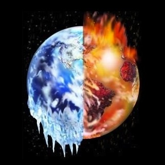
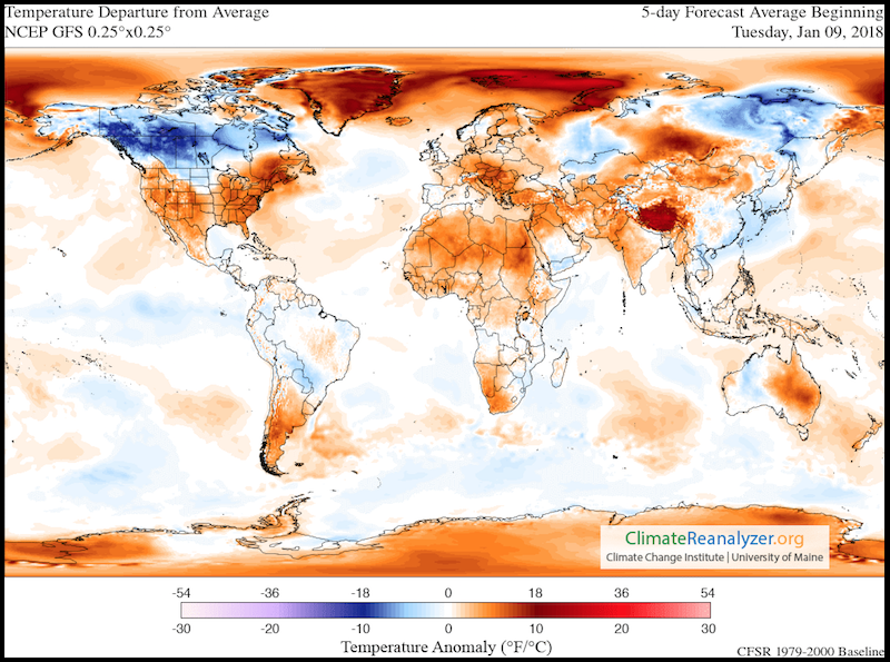
Record Cold In A Record Warm World
The geoengineers are going for broke with the latest all out engineered cool-down of the US. Their Rothschild owned Weather Channel theater and its cast of actors are trumpeting the “freezing planet” headlines, but what is going on with the climate in the rest of the world? The eastern half of the lower 48 states in the US is only 1/2 of a percent of the total surface area of the planet. If that’s only 1/200th of the total surface area, whatever is happening there certainly does not reveal the bigger global picture. Unfortunately, many that live in these “engineered cool-down” zones and many who only watch the corporate controlled media have completely taken the bait. So what is the larger global picture? The just released article below will shed some light on this question. Though the publication below of course does not mention the climate engineering elephant in the room, it does give clear and verifiable facts on the bigger picture.
Dane Wigington
geoengineeringwatch.org
Geoengineered Snowstorms – THE SNOWMEN Turning Warmth Into Winter Part 1
“we are reposting “The Snowmen, Turning Warmth to Winter” because it is imperative that people understand the completely engineered nature of the weather events occurring now across the country and around the globe. There is NO NATURAL WEATHER at this point , virtually none.”
By William Thomas Screenheads clicking into Hollywood’s upcoming distractions can anticipate some improbable sci-fi antics this summer. But make believe can’t come close to what’s happening right over their bowed heads. It’s called “Stratospheric Aerosol Geoengineering” and it means exactly what you’d rather not ask.
Helping The Geoengineers To Sell Geoengineering – Updated Jan 4 2014.

When alternative news sites and their followers jump up and down about “global cooling”, the geoengineers must be opening bottles of champaign to celebrate their success and the efforts of their newly recruited “sales staff”, many of whom are actually anti-geoengineering activists.To push conclusions of “global cooling” because of one very spun data set, without knowing or understanding the true picture or taking into account the effect of ongoing geoengineering on the climate, is to help the geoengineers sell their trade to politicians and leaders around the globe.
NASA goes public with aerosol effects on global climate but geoengineering is completely ignored.

Article disclaimer “NASA’S paid lairs acknowledge the atmosphere is full of aerosols, they acknowledge the effects of those aerosols on the climate, but as expected from time the power structure the major contributing source of the atmospheric aerosols, global geoengineering is completely ignored.”
Geoengineered Snowstorms – THE SNOWMEN Turning Warmth Into Winter Part 1
By William Thomas Screenheads clicking into Hollywood’s upcoming distractions can anticipate some improbable sci-fi antics this summer. But make believe can’t come close to what’s happening right over their bowed heads. It’s called “Stratospheric Aerosol Geoengineering” and it means exactly what you’d rather not ask.
Textbook Disinformation: “Weather Studies”
As astonishing as it may sound, we are witnessing a full-blown disinformation/re-education campaign against the children of the United States. They are being taught that chemical aerosols (geoengineering/”chemtrails”) being sprayed from jets are “harmless water vapor”.</p>

Geoengineering and Ozone Destruction
Again it seems appropriate to wonder what will it take for the gravity of the aerosol spraying to be realized by a larger percentage of the population. What it will take to compel more people to make the spray issue a priority. What it will take to prompt more to take action in order to bring this most dire issue out into the light?
Each and every day the global assault on our planet, and all that lives and breaths, continues. The decimation being caused by the “SAG” (stratospheric aerosol geoengineering) programs can never be quantified. Though the article below, and others like it, do not mention SAG as a causal factor, the mountain of data on the undisputed effects of SAG paint an all too clear conclusion (attached articles).