
“Dramatic Thinning” — Arctic Sea Ice Enters Record Low Territory as Northern Polar Region Heats Up

Source: Robert Scribbler
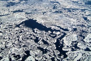
The Arctic sea ice is melting. It is melting far more rapidly than ever expected.
This loss is measured in the form of square kilometers melted, in the form of ice thinned, in the form of new, blue water visible. Yet it is a loss beyond mere numbers and measures. A loss that has a profound impact to the Earth and its climate systems.
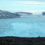
Weather patterns, the rate of warming in the Arctic, the rate of tundra melt, seabed warming, and carbon store release. The rate of glacial loss in Greenland. All are impacted by sea ice loss and related ocean warming.
And today, we mark another new record low. The most recent in a long series, with likely many more thinning ice days to come.
* * * *
Earlier this week there were indications that Arctic sea ice extent may begin exploring new record low values in the Wednesday through Friday timeframe. And the March 4 measure finds NSIDC values sliding below previous records for the date set just 8 years ago.
Ever since Monday, extent values have been falling by an average rate of 10,000 square kilometers each day. A steady progression of warm air fronts through the Barents coupled with well above average temperatures in the Bering and near Alaska region have generated heat pressure along the ice edge and well into the Central Arctic.
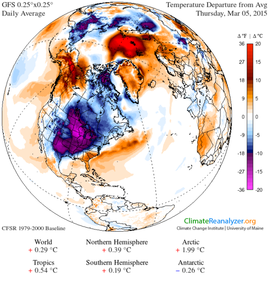
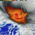
As of today, we have extreme temperature departures in the range of +20 degrees Celsius above average in the Barents northward through to the polar zone. From the Bering through Alaska and into the Southern Beaufort near the Mackenzie Delta departures are in the range of +5 to +20 C above average.

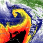
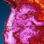
(Polar amplification seen ramping up today in the GFS model analysis provided by Climate Reanalyzer. Exceptional warming of +20 above average occurred in vulnerable sea ice edge regions as extent values dropped to new record lows. Image source: The University of Maine’s Climate Reanalyzer)
These two hot spots, together with another warm pool over Greenland have shoved the Arctic, as a whole, into the +2 C range. A rather high departure that is only forecast to worsen in the GFS model summary over the coming days.
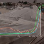
The added warmth, wind, and waves in these ice edge regions drove these extent losses and now, as of Wednesday, values had fallen to 14,383,000 square kilometers. By comparison the previous record low for the day in 2006 was 14,411,000 square kilometers, so the new record is 28,000 square kilometers lower. An area approximately the size of the State of Maryland. 2011 now comes in as third lowest for the day at 14,451,000 square kilometers or 68,000 square kilometers above the 2015 value.
Go back 30 years and the contrast is even more stunning with 1979 extent values for March 4 at 16,514,000 square kilometers. This places the new record fully 2,131,000 square kilometers lower than sea ice extent measures for the same date 36 years ago. A total loss of ice coverage roughly equal to Greenland (2,166,000 square kilometers).

(Sea ice extent for March 5 of 2015 [bottom blue line] drops to record low levels in the NSIDC measure. The other record low years for the date — 2006 [pink] and 2011 [orange] — are provided for reference along with 1979 [top blue line]. Image source: National Snow and Ice Data Center.)
But given the current time of year, a period where ice at low levels has tended to rebound, and given the fact that we are facing growing warmth in key ice edge regions, there is risk that record losses will continue to mount over the coming days.
GFS forecast models show warm fronts continuing to advance along a very strong south to north wind pattern stretching across most of the Atlantic. A wind pattern that today pulls tropical air off the underbelly of a high pressure system just north of Jamaica, funnels this warm air north and eastward over the currents of the Gulf Stream, dumps the flow into a raging low pressure (at 950 mb) just south of Greenland which then shoves the flow into a gale raging north of Scandinavia and south of Svalbard. A strong warm frontal boundary following in the wake of the most recent warm air invasion that, yesterday, swept past the pole.
It’s a meridional pattern stretching from 20 North Latitude in the Tropical Atlantic all the way to 90 North Latitude at the pole. One that features a contiguous frontal boundary stretching from Yucatan Mexico to halfway between Svalbard and Iceland along a daisy chain of lows south and east of Greenland. A flow that is complicit in both melt along the borders of the Barents and ice thinning in the Kara and on past the 80 North Latitude line in the Arctic Ocean.

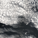
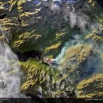
(Amazingly vast frontal system and meridional pattern stretching from the Gulf of Mexico and Caribbean, across the North Atlantic and on into the Arctic. Reference point at 55.6 N and 34.6 W shows storm force winds proceeding almost due south to north. Screen capture in real time at 2:51 PM EST March 5, 2015. Image source: Earth Nullschool. Data Source: Global Forecast System Model.)
This fire hose of warm air pouring up from the Atlantic will intensify over coming days as it fills the bowl of the Barents with heat, which GFS is predicting will balloon northward over the pole. By Sunday the temperature departures are predicted to peak in an extreme +4 C for the entire Arctic.
Most of the heat fueling this departure will come from the warm air invasion over the Atlantic Ocean zone. A secondary, but also very intense temperature departure is predicted to emerge along the Jet Stream ridge pattern stretching to the Mackenzie Delta region. There temperatures will also show isolated spikes in the +20 C above the 1979-2000 average range.
For the sea ice, such departures are very bad timing — hitting vulnerable regions hard just prior to traditional melt season start and possibly developing a rather low launching pad for the 2015 melt season. As such, there is high risk for continuing and expanding record lows for sea ice extent over at least the next five days.

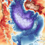
(Global Forecast System Model surface temperature anomaly forecast for Sunday, March 8 shows polar amplification ramping up to an extraordinary +3.99 C for the entire Arctic. Note the extreme positive temperature departures in a very large zone north of the Barents and in the Central Arctic Basin as well as the somewhat smaller but still extreme area of much warmer than normal temperatures over the Mackenzie Delta region. Image source: The University of Maine’s Climate Reanalyzer.)
New Record Lows Amidst Dramatic Thinning
The most recent record lows and threat of these low measures deepening come amidst new scientific reports finding an ominous and extreme thinning of sea ice in the Central Arctic Ocean near the pole. The study found that between 1975 and 2012 Central Arctic Sea Ice thinned from 11.7 feet to 4.1 feet.
Such thinning represents a loss of fully 65 percent of the sea ice volume for the Central Arctic Ocean over this period. But yearly average sea ice thinning paled in comparison to losses seen during September. For that month, sea ice thickness plunged from 9.8 feet to merely 1.4 feet — a stunning drop of 85% over the 37 years of measurements.
Study Author Ron Lindsay of the Applied Physics Lab at UW notes:
“The ice is thinning dramatically. We knew the ice was thinning, but we now have additional confirmation on how fast, and we can see that it’s not slowing down.”
Axel Schweiger, a polar scientist and contributor to the UW study added:
“At least for the central Arctic basin, even our most drastic thinning estimate was slower than measured by these observations.”
A 1.4 foot average sea ice thickness for September is very thin. Tissue paper thin when it comes to sea ice. And the 4.1 foot yearly average isn’t much better. A fragile skein vulnerable to the continued assault of elemental heat we keep driving into the Arctic. Given this major loss, noted fragility, and ongoing exploration of record low values, risks for blue ocean events in this region are on the rise.
* * * *
UPDATE: On March 5, 2015 new record extent lows deepened in the NSIDC measure. By that date extent measures had fallen another 25,000 square kilometers to 14,358,000. The drop deepens losses and widens the gap between 2006 (second lowest on record) and 2015 to 74,000 square kilometers — or an area roughly the size of South Carolina.
Conditions — major heat build up along the ice edge zones, especially in the Barents region — continue to favor suppressed and reduced sea ice levels over the coming days. Updates on this evolving sensitive situation near the start of melt season will continue.
Links:
National Snow and Ice Data Center
The University of Maine’s Climate Reanalyzer
Arctic Sea Ice Thinning Dramatically
Arctic Sea Ice Flirts with New Record Lows
Source: Robert Scribbler


Well, the geoengineers don't seem to care that the hot Caribbean water is racing up the Atlantic north all the way to the Pole! So, is it deliberate? +4 C above average Arctic temperatures overall while the Pole and, curiously, the MacKenzie Delta are + 20 C over normal. This is stunning and scary, but clearly doesn't even make the cut as "news".
Here's the global surface wind animation from Earth Nullschool. It confirms my suspicion that Alaska is not getting any weather fronts from Siberia that I can see. No wonder we're boiling here as well as in the MacKenzie Delta.
One correction concerning the Iditarod Sled Dog Race. This is the second time it was started in Fairbanks, but the first time was 2003. Clearly the Freeze Spraying Brigade has been out all over central Alaska to Nome. The only weather fronts we're getting come from the Gulf of Alaska in the south, so the moisture and winds barely get up to the interior on their own. They barely get up to Anchorage.
Some of the cold and snow Fairbanks received actually came from Canada. East to West–Now there's a trick.
Two people died in Fairbanks last week from exposure, not homeless, one was a UAF student and Alaska Native. It sounded like a flash freeze. I wonder how many people and pets need to die before this is questioned? Do the caribou need to die on mass to wake folks up? I'm very discouraged at the moment, but will nevertheless be fighting on and on.